B.Tech Project. BTP Supervisor: Prof. Manohar Khushalani
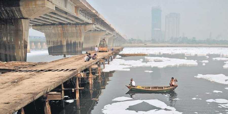
According to the 2018 NITI Aayog Report, Delhi is among 21 Indian cities that is poised to run out of groundwater by 2020. It has also been reported that Delhi has been drawing 25 percent more groundwater than the natural recharge rate. Though it is the job of Central Ground Water to stop the exploitation of groundwater, their actions have not been effective. 60 percent of the water supplied by Delhi Jal Board comes from the Yamuna, around 34 percent from Ganga, and the rest is from groundwater. Yamuna river, the major provider of the city’s drinking water, runs heavy with pollutants and is thick with toxic waste and it becomes toxic because of all the sewage that is dumped into the river.
Manohar Khushalani, Rajeev Babar, Kuldeep Kumar and Sanjeev Kaushik were the four panelists invited for this discussion, for an expert opinion, on the dirty water problem faced in Delhi. This video gives an insight into the perspective of the general public and how they’re facing this problem.
TV9 has conducted surveys in 8 parts of Delhi, namely, Laxmi Nagar, Sangam Vihar, Chandni Chowk, Lajpat Nagar, Pitampura, New Delhi, Narela, and Yamuna Vihar. During this survey, they have asked people about their opinions on a few questions about the water and air pollution in Delhi. More details on this is given below.
They had also collected water samples from these areas and gave it for testing. After the results came out, they found out that all the samples that were collected from the 8 parts of Delhi which were surveyed had contaminated and undrinkable water.
Questions asked by TV9 to general public:
Is the water that you receive dirty or unfit for drinking?
Yes
No
Don’t Know
Laxmi Nagar
80%
7.5%
12.5%
Sangam Vihar
75%
15%
10%
Chandni Chowk
80%
15%
5%
Lajpat Nagar
80%
16%
4%
Pitampura
57.5%
35%
7.5%
New Delhi
90%
5%
5%
Narela
92.5%
5%
2.5%
Yamuna Vihar
45%
40%
15%
This means that on an average, 75 percent of the people said yes, that the water they receive is unfit for drinking, 17.3 percent said no, the water they receive is fine and the rest of 7.7 percent said they’re not sure.
Does the dirty water make your family fall ill?
Yes
No
Don’t Know
Laxmi Nagar
75%
7.5%
17.5%
Sangam Vihar
82.5%
12.5%
5%
Chandni Chowk
72.5%
10%
17.5%
Lajpat Nagar
70%
20%
10%
Pitampura
55%
40%
5%
New Delhi
90%
7.5%
2.5%
Narela
95%
2.5%
2.5%
Yamuna Vihar
50%
47.5%
2.5%
This means that on average 73.8 percent of the people said that yes, the dirty water makes some of the family members fall sick, 18.4 percent said no, it doesn’t make them fall sick, and the rest 7.8 percent said they’re not sure.
Do you want to leave Delhi because of the water and air pollution?
Yes
No
Don’t Know
Laxmi Nagar
52.5%
42.5%
5%
Sangam Vihar
75%
17.5%
7.5%
Chandni Chowk
70%
25%
5%
Lajpat Nagar
60%
36%
4%
Pitampura
32.5%
65%
2.5%
New Delhi
55%
32.5%
12.5%
Narela
70%
7.5%
20%
Yamuna Vihar
37.5%
47.5%
15%
This means that on an average, 57 percent of the people said yes, they want to leave Delhi, 34.1 percent said no, they’d like to stay there itself and 8.9 percent of the people said they’re not sure.
Do you feel the air in your locality is still polluted and it’s becoming hard to breathe?
Yes
No
Don’t Know
Laxmi Nagar
82.5%
15%
2.5%
Sangam Vihar
80%
15%
10%
Chandni Chowk
85%
10%
5%
Lajpat Nagar
68%
30%
2%
Pitampura
82.5%
12.5%
5%
New Delhi
92.5%
2.5%
5%
Narela
90%
2.5%
7.5%
Yamuna Vihar
87.5%
7.5%
5%
This means that on an average, 83.5 percent of the people said yes, they feel the air is polluted and it is becoming hard to breathe, 11.8 percent said no, they do not find it hard to breathe and the rest 4.7 percent said they’re not sure.
Lok Sabha TV conducted a panel discussion on the study on Water Management of the Indus River System and its Implications for India’s Foreign Policy. The invited panelists were Prof. Manohar Khushalani, Sushant Sari and Akshay Singh.
Manohar Khushalani started the discussion by describing the Indus Water Treaty.
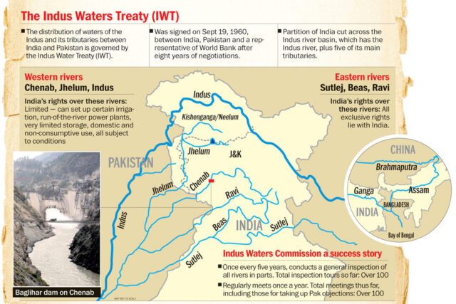
The Indus Waters Treaty is a water-distribution treaty between India and Pakistan, brokered by the World Bank, to use the water available in the Indus System of rivers. It was signed on 19 September 1960 by Jawaharlal Nehru, the then Prime Minister of India, and Ayub Khan, the President of Pakistan.
Eastern Rivers
Sutlej
Beas
Ravi
Western Rivers
Jhelum
Chenab
Indus
The Treaty gives control over the waters of the three eastern rivers — the Beas, Ravi and Sutlej with a mean annual flow of 33 million acre-feet (MAF) — to India, while control over the waters of the three western rivers — the Indus, Chenab and Jhelum with a mean annual flow of 80 MAF — to Pakistan. According to treaty, all the water of eastern rivers shall be available for unrestricted use in India. India should let unrestricted flow of water from western rivers to Pakistan. This does not mean that India cannot use the western river’s water. They are allowed to use it for limited irrigation and non-consumptive needs such as for generating electricity. This means that the treaty has allocated Pakistan 80 percent of the water from the six-river Indus water system. China has been kept out of the treaty even though Indus originates from Tibet because the topography of the Indus Water System does not allow China to change or stop the flow of the water. Neither of the countries can unilaterally walk out of the pact.
Indus Water Treaty is considered to be one of the most successful water-sharing endeavours in the world today. For 56 years, both India and Pakistan have been peacefully sharing the water of Indus and its tributaries, thanks to The Indus Water Treaty (IWT). But since the ratification, there have been a number of issues raised by both countries over the ethical use of the treaty and the water itself.
India has always treated the security issues and water issues as 2 different subjects.
The discussion also gave insights into the disputes and objections raised over this treaty.
The most frequently raised issue by Pakistan is that India can stop the water flow to Pakistan. Can India stop the water flow to Pakistan? No. Not as per the treaty. India can only utilize the provisions of the treaty to reduce the water flow by a small number but cannot completely stop the flow. India has in fact built many hydro power projects to which Pakistan has objected repeatedly. Even if India decides to reduce the water flow by a large amount, they do not have enough infrastructure to use the additional water and it may even create floods in Kashmir. The decision of not giving water to Pakistan may further enrage the terror elements in the country, making them intensify their attacks on India. This decision can also affect India’s relations with other countries like Nepal and Bangladesh with whom they have water treaties as well.
Most of the issues have been resolved with legal procedures and mutual understanding from both sides. Though after the 2016 Uri attacks, India threatened to revoke the Indus Water Treaty but so far the threats have not been materialised.
NDTV 24×7 conducted a live debate on 18th June 2019 from 8.30 to 9 pm. The Program was titled Reality Check. It was anchored by Vishnu Som. The panelists in the discussion were S Muralidharan, Prof. Manohar Khushalani and TKS Elangovan.
Please Also Subscribe To Our YouTube Channel OneVorld by clicking below
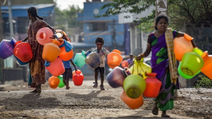
NDTV has conducted a survey in chennai asking the general public about various problems that they are facing related to water. The residents then told the channel that they have to wait for hours in line to collect some water for every 2 days. Some of them even said that they don’t get enough water to bath.
According to a london-based risk analytics firm, Chennai is facing “the most extreme risk” of water stress and that this situation could be the new normal for millions of people. Chennai, he said, gets an average of 54 days of rain per year, yielding an average rainfall of about 140 centimeters (55 inches). Its failure to collect the rain that falls, especially during poor monsoons such as that of last autumn, leads to what he called a “man-made” crisis of scarcity. Less than four years ago, Chennai saw devastating floods that took at least 422 lives in Tamil Nadu and caused up to $14 billion in damages. But most of that rainwater flowed into the sea, lost forever to Chennai’s parched groundwater reserves. As the coastal city anticipates its upcoming autumn monsoon season, residents and experts have criticized authorities for failing to rehabilitate a notoriously mismanaged water supply.
Unless we capture the rain that falls in those monsoon days, we will run out of water
Manohar Khushalani stated that the big factors that have led to this crisis in Tamil Nadu are deforestation and mining, in other words construction of buildings for development is in the process.. These types of constructions have halted the recharge of lakes and reservoirs that supply water to the households, and since the recharge has stopped, the major lakes and reservoirs have gone completely dry. Even the amount of rainfall has been declining and that amount was not enough to recharge the lakes.
Water tankers are being called into most of the areas of Tamil Nadu which are facing drought. However, government tankers can take up to a month to appear after requested, so some families, wealthy residents, and business owners have opted to pay for costly private water tankers. The poor who live in slums do not have this option; a family in Chennai’s slums may receive as little as 30 litres (7.9 US gallons) of water every day compared to an average American household which uses 1,150 litres (300 US gallons) of water a day.
S Muralidharan mentioned the fact that Tamil Nadu contains 6 percent of India’s population and it covers 4 percent of India’s land area but still the state only receives 2-2.5 percent of the water provided. This tells that Tamil Nadu has already become a dry state and is facing water crisis currently.
What steps have been taken to improve the situation?
The Chennai Metropolitan Water Supply and Sewage Board, which is responsible for the city’s water supply, has pushed for lakes to be desilted, allowing them to be used for water storage. The state government said in response it has begun to set up 270 water purification centers and has recently begun construction on Chennai’s third desalination plant, after which the government said the city will no longer have to rely on monsoon rains.
Under former Chief Minister J. Jayalalithaa, who served in the role for over 14 years, Chennai made rainwater harvesting compulsory, requiring every building to install a water catchment system on its rooftop and pour the collected rainwater into the ground. However, when a survey was conducted regarding this, only 40 percent of the buildings were found to be complying with this law. The following three years brought heavy rains and, he said, dramatically raised the groundwater level, filling dry open wells for the first time in decades. Though the 40 percent compliance rate was a good start, it wasn’t good enough for the state to come out of the water crisis.
The city already has two desalination plants with capacity of 210 million litres a day that service the northern suburbs. A third 150 million litre plant costing nearly Rs 1300 crore would be ready next year. 2 new recycling plants are also being built which will have a capacity of 120 million litres a day. This will free up domestic drinking water supplies and reduce the reliance on the already stressed ground water resources.
Watch More Programs on this Subject by clicking on the playlist below:
A Case of ” To Be Or Not To Be A Fit Site For 300m Deep Dam Foundations”
PUNATSANGCHHU-I DAM – RIGHT BANK FAILURE
You can listen to the Presentation and discussion on the failure of right bank at Punatsangchhu-I dam site, held on DDAG Open House, given at link : https://lnkd.in/dPGjpJk
( First of the incidences of a chain of massive surprises in the two Punatsangchhu Projects in Bhutan )
– Huge Setbacks Due To Failed Assessments Of Geology & Rock Supports
There is a strange coincidence of huge rock mass failures, which happened in the two mega hydroelectric projects named Punatsangchhu -I & II H E Projects, under construction since 2009 -10 in Bhutan.
The Punatsangchhu-I Hydro Electric Project (PHEP-I) a 1200 MW project with scheduled commissioning date of year 2016 and at sanctioned cost of Rs. 35146 millions and new approved Cost of Rs. 94000 millions (US$ 1.34 billions), is expected to have further escalating its cost possibly to Rs. 121000 millions (US$ 1.74 billion). The Head race tunnel and Desilting Arrangement lying completed since 2015, Powerhouse complex 98% ready have an already incurred cost of about Rs. 80000 millions .
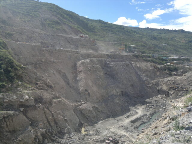
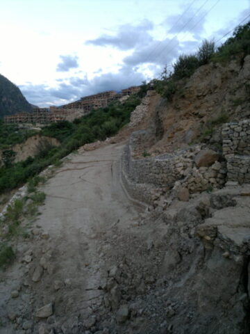
However, even the start of concreting for construction of 136m high dam is a big uncertaintyafter its Right Bank suffered a massive slide with continued movement of the big hill mass about 500m height towards valley and downstream by 5m and vertically subsiding by 5m in a week in July 2013.The hill mass movement has continued at slower pace for more than year, sliding on SZ-2 Shear Zone.
A whopping cost of about Rs. 30000 millions, out of above cost, may get attributed to extra works necessitated because of ” geological surprises”.
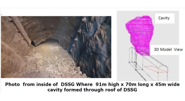
The Punatsangchhu-II (PHEP-II), a 1020 MW project with scheduled date of commissioning of year 2017 at sanctioned cost of Rs. 37778 millions and a new approved project cost of Rs. 72900 millions ( US $ 1.04 billions), possibly to be further escalating to Rs. 80000 millions ( US $ 1.14 billions), with already incurred cost of about Rs. 65880 millions is delayed due to the huge rock mass failure in its underground Downstream Surge Gallery (DSSG), resulting in a huge cavity of about 91m height x 70m length and 45m width in the crown of the DSSG. The Dam foundations had encountered, a thus far unexplored,mega shear of maximum 30m width, cutting across the length all the 4 dam blocks diagonally. The shear zone with its about 35ᵒ to 45ᵒ dip, continued under the foundations to large depths.
Again a whopping cost of about Rs. 15000 millions, out of the above cost, may get attributed to extra works necessitated because of ” geological surprises”.
Occurrence of too many geological surprises, which were blamed for the big mishaps in the two mega Projects,intrigues one to investigate if ‘ harping on thegeological surprises‘ may only be a scapegoat for the lack of proper geological investigations done by the Consultants and inappropriate design of rock support measures done by the Designers, who were the same for both the Projects .
The Case of Punatsangchhu-I H.E Project Dam Right Bank Failure :
1. Selection Of The Dam Site Without Detailed Geological Investigations
( the first miss)
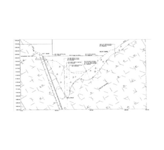
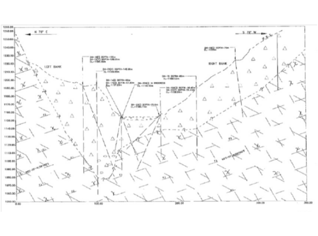
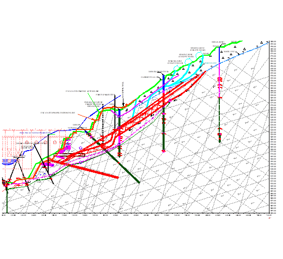
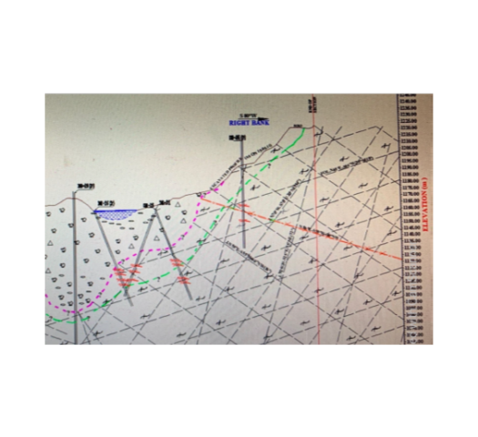
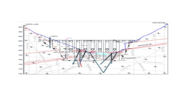
The present dam site was selected in 2009 at a new site, located 1.5km upstream of the original site which was considered in the Detailed Project Report (DPR). The shifting of location to the new site was done just before taking up the Tender activities of the Project. The selection of this new site was done on the basis of some geological explorations done at different times earlier, apparently with a purpose of studying geological conditions of the reservoir rim. The Tender Drawings of Geological Details, issued in 2009 , showed the geological conditions that were based on the limited exploration done till that far. The Tender stage geological drawings at the dam axis and at various sections upstream and downstream indicated no Shear Zone to be encountered. The tender stage Geological Sections at Dam axis and at 100m downstream are placed at Fig -1 and Fig.- 2 below.
Tender Stage Geological Drawings of 2009 Show no Shear Zone in Right Bank :
Tender Drawing of Geological Section At Dam Axis Fig.- 1
Tender Drawing of Geological Section At 100m D/S of Dam Axis Fig.- 2
No Shear Zone Shown in 2009 Tender Drawings
2. Geological Assessment done By The Consultants in 2011 , At Design & Construction Stage Did Not Detect The Presence Of The Massive Shear Zone And Delineate Continuity Of The Shear Zone In to Hill At Vulnerable Dip :
( the second miss)
The Geological Investigation at the present Dam site was carried out during 2010 – 11 by the Consultants after issue of Tender Specification Drawings for deciding the stripping limits and designing the rock support system for excavation of the dam pit. The excavation for the 136m high dam foundations involved excavation of a depth of 300m.
Earlier Consultants had shown lacksidal attitude when they did not carry out detailed Geological Explorations for Selection of Dam site in 2009. This was followed, apparently, yet by a limited explorations done in 2010-11 to decide the stripping limit and design the excavation support details of the right bank slope of 300m excavated depth.
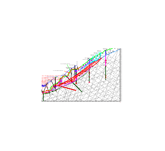
Did TheConstruction Stage Geological Drawings of 2011 Missed To Connect Intercepts of Sheared Rock Mass In Drill Holes And Delineate The Steep Show Shear Zone in Right Bank ??
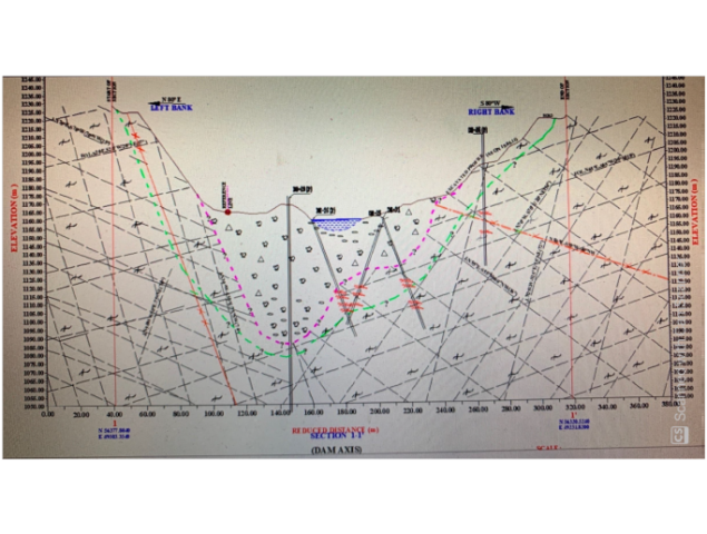
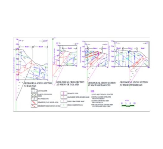
Geological Section At Dam Axis – As Per 2011Investigations Fig.- 3 Sheared Rock Mass Intercepts Recorded in Drill Holes
The sheared rock mass intercepts were recorded in the Drill Holes DH25, DH31 located at dam axis and DH26 located at 20m D/S of Dam axis and in drill holes at further downstreamin the geological investigations carried out by the Consultantsduring construction stage for excavation support designs .
Apparently the Consultants had failed to connect these intercepts of sheared material found in different drill holes to establish the extent and the vulnerable dip the major shear zone would have, though they had detected presence of the sheared rock material in these explorations.
Logically, after the sheared material was intercepted in different drill holes, it should have been investigated whether the intercepts were a part of one single Shear Zone. More exploratory drill holes may have been done further up the hill to connect the intercepted sheared material incidences and delineate the attitude of the Shear Zone, of which these intercepted shear material could be possibly a part of. Thus the inaccurate geological assessment was made by missing to interpret and detect continuity and rising dip angle of the major Shear Zone in right bank of PHEP-I dam site.
The required further geological investigation doesappear to have been missed by Consultants despite that the Resident Geologist of Project Authority had provided the Consultants the following detailed geological note which clearly mentioned presence of shear zones and brought out the possibilities of slides happening on the shear zone.
3. Geological Assessment by the Project’s Senior Resident Geologist, at Construction Stage in 2011, Reported Presence of the 1.5m Thick Shear Zone , Prone To Sliding And Its Need for Proper Strengthening Which Was Neglected By The Consultants :
( the third Miss )
The Geological Report of 2011 of the Sr. Resident Geologist of the Project is reproduced below :
“The strata shows small scale, S- shape tight folds and broad warping of the beds at places, indicating that the rock strata has undergone the polyphase deformation in the past leading to development of numerous criss-cross structural discontinuities like joints, shears etc. of different orders. Five prominent and two random joint sets are recorded in the right bank. The foliation is very close to moderately spaced from 2cm to 60 cm and dips towards valley slightly in d/s direction; however rolling of dip is observed at places, there it dips into the hill due to folding and warping. The general topography and gentle natural slopes on the right bank of river are controlled by low and valley ward dipping foliation planes.
The drilling data on right abutment has indicated the presence of numerous thick deformed/sheared zones/schistose rock mass having very poor RQD (below 30%) and nil to poor core recovery (below 40%) at different depths. Such rock mass is fissile and fractured, which breaks along foliation and other prominent joints and has very low strength. One deformed zone/band (1m thick) along foliation is delineated at Ch. 13m d/s of dam axis at El. 1220m and at Ch. 23m d/s of dam axis at El 1205m and dips at 150-250 in the downstream.
A ± 15m thick band of fractured, biotite rich gneiss with schistose partings and sheared seams, which dips gently towards valley along foliation was delineated during drilling and is expected to expose in all along the foundation of dam block nos. 7, 8, 9,10 &11, and below the foundation of block nos. 12 and 13. The core recovery and RQD in this rock mass are very poor. Such bands striking parallel to the flow and dipping towards valley may form passage for water and are prone to slide under forces, hence require proper treatment during excavation.
Another shear zone (± 1.5m thick), which was encountered in the drift strikes from d/s to u/s and dips gently into the hill slightly towards upstream. This shear zone is expected to expose in the foundation of dam block no.11 at El ±1165m and below the block no. 12 along its dip & in the reservoir along its strike in the upstream. Such shear zone also needs proper treatment and strengthening as they form the avenues for water draining from reservoir and development of the hydrostatic pressure.
Layered/stratified/foliated rocks with softer beds (schistose partings/shear zones) confined between harder beds are always prone to shear stress problems/sliding, which inevitably develops in the rock in conjunction with pressure/load.“
Geotechnical Problems Identified in the 2011 report of the Resident Geologist :
Layered/stratified/foliated strata with soft bands confined between hard rocks.
Occurrence of folds and warping indicating the signs of deformation and presence of local stress areas.
Presence of thick shear/fracture zones and biotite rich bands of gneiss/schist having very low strength and less RQD.
Moderately jointed and very blocky nature of the rock mass with steep joints having longer continuity and persistence, striking along the flow direction.
Valley wards dipping foliation and prominent open joints.
Formation of wedges due to intersection of the prominent joints.
Presence of the parallel discontinuities with variable zones of permeability. Moderate to high lugeon values indicating the fracture permeability and fissured rock mass.
Lowtomoderatestrengthofrockmass.
The above report shows that there was adequate warning given in the 2011 geological report by the Resident Sr. Geologist of the Project Authority of a 15m thick fractured rock mass present all along the foundations of dam blocks 7,8,9,10,11 and 12, with shear seems and dipping in to the valley, having potential of sliding . The report also informed of the 1.5m thick Shear Zone dipping in to the hill which would be getting exposed in excavation of dam blocks 11 and 12 . The report further warned that the layered/stratified/foliated rocks with softer beds (schistose partings/shear zones) confined between harder beds are always prone to shear stress problems/sliding.
The report specifically asked to provide adequate support and treatment which apparently was not so designed.
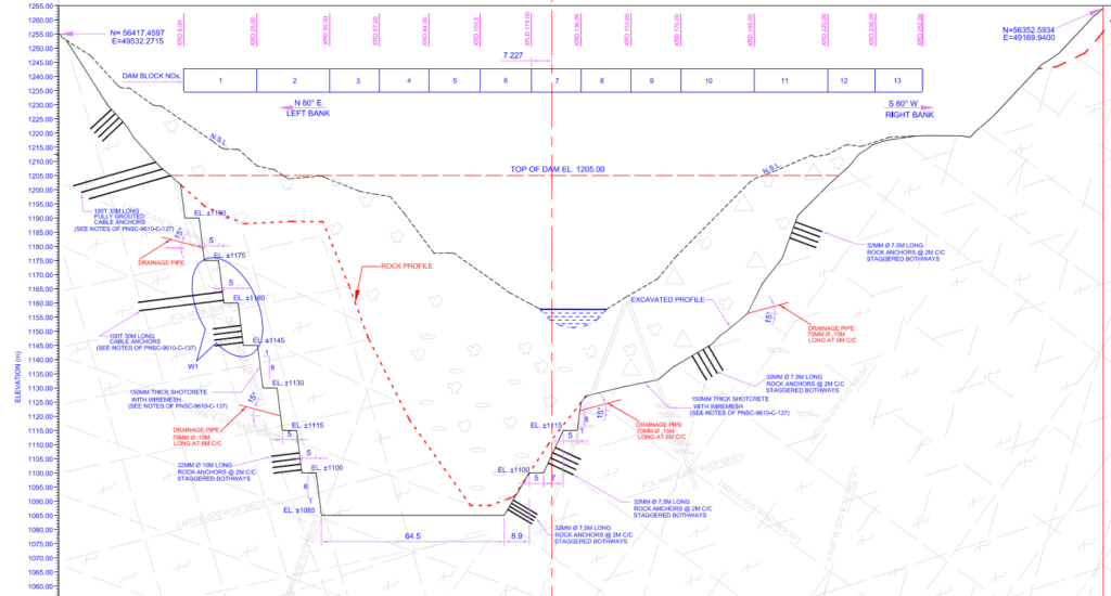
The Rock Support Measures comprising only 150mm shotcrete and 32mmDia. 7.5m Long rock anchors , would have been designed in 2010 -11 based on the limited information gathered by the Designer / Consultant and not inferring and analyzing the sheared rock mass occurrences as a Shear Zone. Probably the Cable Anchors may have been found required to be provided , if analysis of the excavated slope would have been done incorporating the Shear Zone. However, there were no cable anchors designed for the Right bank excavation support, while provisions of cable anchors were done in Left bank excavation profile. Therefore, the rock anchors and shotcrete would have not been designed to hold the excavated profile of the Right abutment against a potential slide on the shear plane, as no such Shear Zone had been identified by the Consultants till that time. The designed provisions thus must have been under provisioned to safeguard a 300m deep excavated slope against the later resulted Massive Failure of Right Bank during its excavation in July 2013.
No Provision of any cable anchors in Right Bank Slope, unlike those provided in Left Bank Slope Fig. – 4
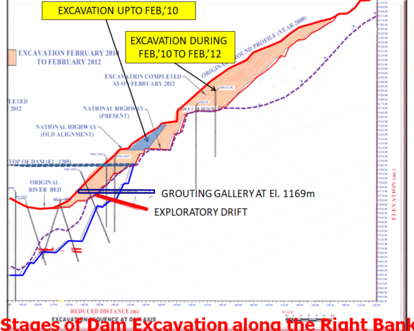
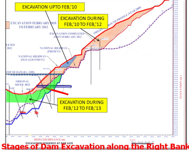
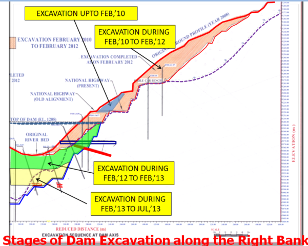
4. The Excavation Stages From 2010 To July 2013
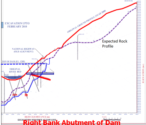
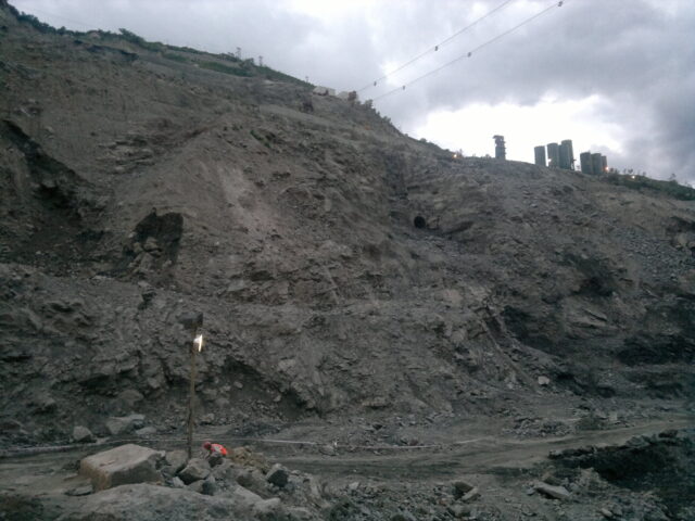
The Right Bank slope excavated to a depth of 250m till June 2013 stood intact Figs. 5 to 8
The Right Bank Slope when excavated further in July 2013 for another 10m, extending the excavated depth to about 260m , exposed the Toe of Shear Zonedipping at 450 in to the Hill Fig. – 9
5. Incidental Identification of the Presence of the Shear Zone :
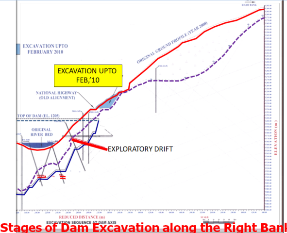
Considering the weak rock mass condition, a 5.5m x 5.5m wide and 60m long gallery/tunnel with 15m long x-cuts in upstream and downstream side was excavated in right abutment (Dam Block-13) at invert El 1169m, in 2011 to February 2012, for consolidation grouting.
Until July 2013, the excavated Right Bank Profile stood intact with provided support comprising 32mm Dia. 7.5m long Rock Anchors and 150mm Shotcrete.
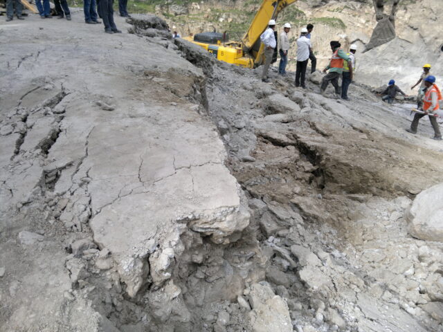
It was on around 10 July 2013 , subsequent to a Shear Zone getting exposed, that a few cracks were observed on the road surface which goes winding up on the Right Side Hill of the dam site, leading to the Project colony. Also the steel rib supports provided in the Grouting Gallery, at El. 1169m in the Right Abutment, were seen to be twisted and the invert floor of the Gallery was seen to have settled and developed cracks.
Immediately a team of the Consultants and the resident geologists of the Project visited the Grouting Gallery and prepared the following Geological Note based on their field observations :
6. Geological Assessment Note given by the Consultants on 12th July 2013 after observing cracks & Settlements in the Grouting Gallery in Right bank , Reported presence of Shear Zone Affecting 1.5m ~6.5m Thickness & dipping 250-450/N010-040 :
The Geological assessment Report of 12 July 2013 is reproduced below :
“ The entire excavated reaches of the grouting gallery and x-cuts have been supported with steel ribs (200 x 100mm) @ 1m spacing. The final lining and grouting through the gallery is yet to be done. Recently some settlement/deformation is noticed in the gallery and x-cuts. Hence a joint inspection visit was made to the site on 12th July, 2013 for geotechnical assessment and remedial measures. The rock mass exposed in grouting gallery and x-cuts is jointed, very blocky and weathered quartz-biotite gneiss with thin schist bands and shear zones. The rocks are deformed in the form of folding and warpings and distressed in the form of open/wide/stress relief joints.
The rock mass encountered falls inpoor to very poor grade category (Rock class IV and V). One major shear/deformed zone (Clay gouge 30-200cm, affected zone 1.5 to 6.5m) dipping 250-450/N010-040 cuts across the gallery from RD 27m (left wall) to RD 48m (Right wall) and over the crown beyond RD 50m. Shearing effect is more beyond RD 34m as it forms hinge portion of the fold. This shear/deformed zone strikes from d/s of dam (closer to valley) to u/s of dam (Farther to valley) and as per projections it was expected to cut in u/s x-cut between RD 15m (Crown) to RD 35 (left wall) with less horizontal cover on right wall.
The location and pattern of the settlement/deformation occurred corresponds to the disposition of the major shear zone in the gallery and x-cuts and mobilisation of its broken zone under pressure. The shear zone is low to moderate dipping and runs oblique to the main gallery from left to right wall along strike.
Such settlements are time dependant deformations in weak/soft rocks occurred after completion of the excavation and installation of the primary support depending upon the load/pressure; stand up time of the rock mass and support provided.
Once commenced, such deformations tend to increase with the time if structure is not provided with the strong support.”
The Consultants noticed presence of the major Shear Zone, for the first time, in July 2013 only during inspection of the Grouting Gallery. Where as, the Sr. Resident Geologist of the Project Authority had already informed of the 1.5m thick Shear Zone dipping in to the hill which would be getting exposed in excavation of dam blocks 11 and 12, in his note provided to the Consultants in 2011. This Shear Zone had did get exposed, in July 2013, at El. 1110m in excavation of dam block no.12.
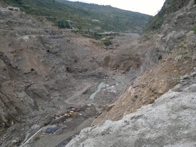
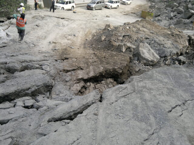
7. Massive Slide of 500m high x 300m long Hill Mass in Right Bank on 24 July 2013 :
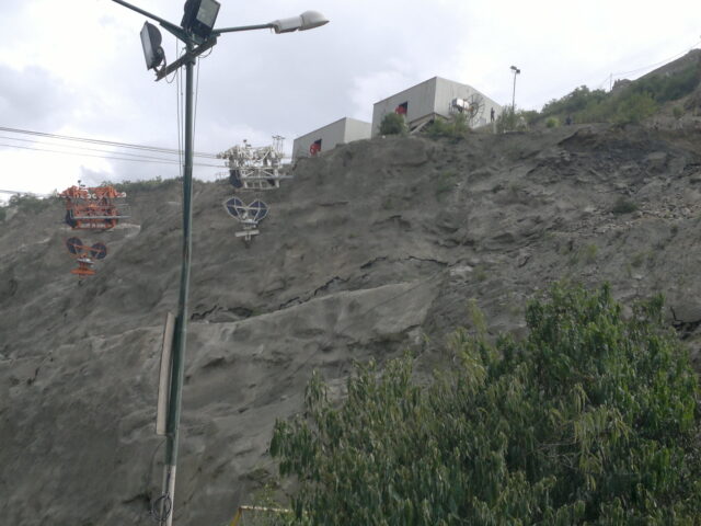
Soon after the settlement/deformation was noticed in the gallery and x-cuts in the Right Bank, a massive slide in the Right Bank occurred which detached a hill mass in Right bank of a reach 500m in height , 300m in length and moved it over 5m towards the valley and 2m along the flow with 5m vertical subsidence. Cracks of about 10m to 15m depth appeared on the road and hill slope.
Hill Mass in a reach of 500m height , 300m length moved by 5m towards valley, 2.5m towards D/S side and settled by 5m
The right bank failure resulted in huge hill mass slide, causing separation of hill mass of about 500m ( 1/2 km) height , 300m length and 40-50m in its thickness under the ground surface. The slide created about 10m deep fissures at the top levels of slip in this stretch of the hill mass. This reach of the hill suffered subsidence/ settlement of the hill by 5m vertically and moved en-mass towards the river side by 5m and along river in downstream direction by 2.5m.
Deep Fissures, Subsidence and Slips at surface observed as spread over stretch of 500m height and 300m width of Right Bank Hill
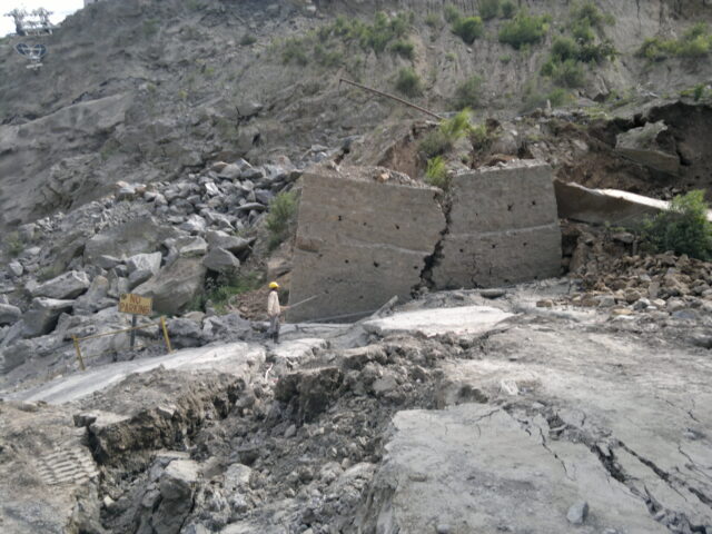
The photographs below show the sagged Cable Car rope due to subsidence of foundations of their end anchorsprovided at a bench at El. 1250m in the Right Bank
The cable of the Cable Car sagged due to subsidence of the benches in the Right side hill where the foundation blocks of their end anchorage were laid
8. Delineation of the Shear Zone in the Right Bank
The hill mass stretch of over 500m height in a 300m length kept moving at faster pace for four days period, resulting in a shift of the separated big hill mass over 5m in to valley and over 2.5m along the direction of flow of river with a subsidence of the hill mass of 5m. The movement of this hill mass continued at smaller pace for days , weeks and months to follow. The hill mass seemed to have had slid over the Shear Zone. However the extent of the Shear Zone extending in side the hill was not known at that time. The cracks and fissures of about 10m depth had surfaced at locations as far till about 500m height of the hill.
The outer boundary of the hill surface affected by the massive slide was marked. A total 23 numbers of drill holes , running a total depth of 3500m were driven along the boundary of the slide affected area. The Shear Zone was delineated from the core logs .
The delineated major Shear Zone with clay gouge 30-200cm, affected zone 1.5 to 6.5m is dipping 250-450/N010-040 (The excavated profile as existed post slide is shown in green color line) Fig. – 10
Comparison of Geological Assessments Done By TheConsultantsIn 2011 Investigations V/s Actual Geological Conditions Encountered & Established in 2014 After The Massive Slide :
The Sheared Rock Mass Intercepts Were Not Inferred, By The Consultants In 2011, To Be A Shear Zone Continuing In To The Hill Fig. – 11
The Shear Zone SZ2, Delineated As Dipping Sharply & Deeper In To The hill Was established Through Additional Holes In 2014 , Only After 2013 Slide Fig. – 12
9. Synopsis of the Geological Investigations Done in 2009, 2011, 2013 and 2014 :
The Consultants had failed to detect and delineate the shear zone in the geological investigations forming the basis of selection of the present dam site in 2009.
The Resident Geologist reported in his Note in 2011, the presence of a shear zone SZ-2 assessed by him from the geological explorations done in 2011 for detailed design of slope excavation supports. But the Consultants / Designers had failed to build on gathered information and thus ignored to do further exploration to identify and delineate the continuity of the major Shear zone which extended in to the hill at a vulnerable dip angle.
The Resident Geologist had reported, in his Note in 2011, of potential risk of slide along the Shear Zone and suggested proper strengthening. The Consultants apparently failed to do a slope stability analysis for the potential destabilised condition of the excavated slope in the Right bank arising from presence of the steeply dipping major shear zone, despite its warning given by the Project Authority.
Therefore, the Consultants failed to design the appropriate support measures required to be provided during progress of excavation of the Right Bank, to ensure stability of the Hill Mass against hazard of a potential slide of the big hill mass , which eventually slid en-mass in its 1000m height, 300m length and about 30-40m depth inside the hill.
Incidentally the Cable Anchors were provided at various levels in the Left bank excavated slopes, but the Consultants failed to establish the need of design and provision of Cable Anchors in the Right Bank to hold the endangered hill mass, which eventually separated out in the Right Bank and slipped over the Shear Zone.
After the slide, a total of 3500m of length in 23 numbers of drill holes were done in 2014, along the boundary of the affected hill mass , which delineated the alignment of the shear zone.
A more intelligent inference from the Sheared material intercepts in the drill holes done in 2011, would have established the need of a few more drill holes and detected continuity of the shear zone SZ-2 with its dip risingng sharply in to the Hill.
It may be seen that firstly there was lack of Geological Information gathered for selection of the present dam site. Thereafter, the inaccurate Geological Assessment was made by Consultants from the explorations that were carried out at the Construction stage for Designs of stripping limits of the excavation and Support Designs in 2011. Missing toconnect the sheared material intercepts in detection of the Shear Zone had resulted in under provisioned design of the rock supports. The designed 32mm dia. rock anchors of 7.5m length were no match to and too insufficient than the required measures e.g. longer cable anchors like those provided in the Left bank . Thus the inappropriate and inadequate rock supports led to the major hill mass slide in the right abutment of PHEP-I dam, during its excavation in July 2013.
The slid hill mass has been in motion for years thereafter, though at much slower pace, despite a number of measures designed by the Consultants and implemented in the field to stall the movement of the hill . A number of more slides have happened in the downstream of the main slide, after 2013 till recently in 2018.
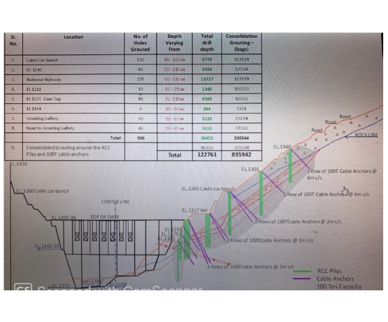
10. Strengthening Measures Implemented In Right Bank After Slide :
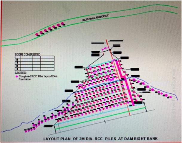
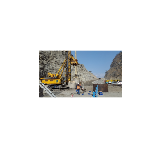
The Strengthening Measures Executed For Arresting Movement of Hill Mass: Consolidation Grouting, 325mm dia. Steel Encase Micro Piles, 100 MT Cable Anchors & 2m Dia. RCC Piles Fig. – 13
Fig. – 14
After the slide, the Consultants designed installation of about 1050 numbers of 300mm dia steel encased micro piles from 11 different levels as a strengthening measure for the destabilised hill mass.
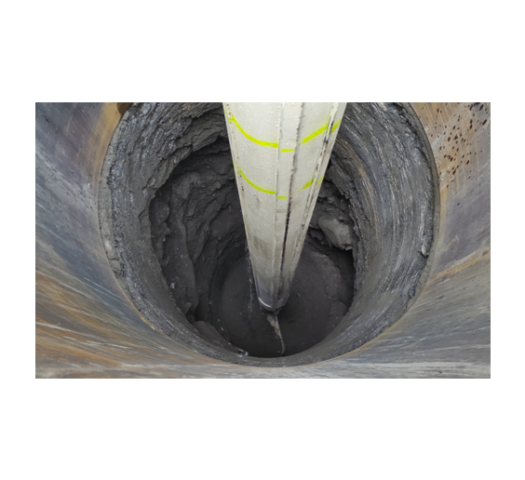
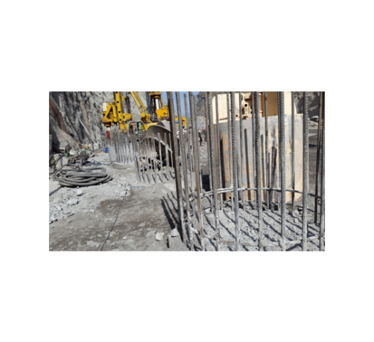
Further also subsequent to the hill mass slide, bout 250 numbers of 2m diameter steel reinforced RCC piles of depth varying from 50m to 85m were driven from various levels along the excavated slopes. Each of these RCC piles were socketted in to sound rock for 10m length beyond the Shear Zone.
About 50,000 MT of cement was consumed in grouting the slipped hill mass, carried out through 566 numbers of drill holes, totalling together to 123 kilometres of depth, to improve the deteriorated quality of the disturbed hill mass in local vicinity of dam axis after the slide as a strengthening measure.
Also 1000 numbers of 100 MT capacity Cable Anchors from 12 different levels were installed.
Important Observation :
It was experienced that during many instances of drilling, undertaken for installation of micro piles, the drill rod/ shaft used to drop for one to two meters depth, by itself without requiring any drilling effort, thereby indicating that the entire hill mass in the Right bank has been rendered geologically further weak & poor and porous resulting from the massive movement of the hill mass.
Execution of 2m Dia. RCC Piles of 45m ~ 85m Length
11. Present Status in June 2020 :
The right abutment hill continued to move for years after implementation of all of the above mentioned strengthening measures , but at reduced pace. The 2m dia piles too may have suffered some deflection.
Norwegian Geotechnical Institute (NGI) has advised for off loading the right abutmentby excavating and removing a huge part of overburden from the right abutment, starting from much higher levels, to improve its stability against sliding.
A proverbial “stitch in time” in 2011 by adopting an adequate investigation, appropriate analysis and design by the Consultants may have saved from occurrence of massive rock failure in the Right abutment.
The actual construction of the dam having halted since 2013, despite various strengthening and rehabilitation works being attempted to rescue the situation, there have been two more slides in the Right Bank in the immediate downstream of location of the massive slide of 2013 .
However, after 7 years of the massive slide which happened in July 2013, even the start of concreting for construction of 136m high dam is a big uncertainty as of now in 2020. With about Rs. 80000 millions spent already, the future of the Project apparently hangs in uncertainty as of now.
There remains a point of debate that with given geological conditions in the Right bank, whether this site was a fit site for implementing excavation of 300m depth ??
Moreover, the “churning” of the rock mass with in the hill, affected by the massive rock mass movement, which pushed the hill to over 5m, possibly would have created many voids in the rock mass. It can be adjudged so from what was indicated by many an incidents of self dropping by a meter or so, of drilling rig shaft, experienced while driving 325mm piles in the slid mass. Therefore, it may also be debatable that whether this Right Bank be making a safe and a water tight abutment for a 136m high dam??
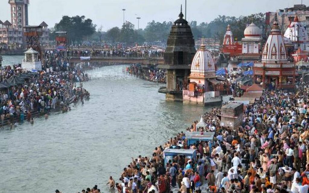
WhatsUp In the Name of Ganges? asks Manohar Khushalani / News24
IIITD Student B.Tech Project. BTP Supervisor: Prof. Manohar Khushalani
Prof. Manohar Khushalani with co-panelists Mahamandaleshwar Martand Puri and Mr. Rajya Sarai discusses the issue of cleaning Ganga on a live program conducted by News24.
Cleaning of the life-giving river Ganga has been a hot topic for so long, that it doesn’t even surprise anymore. With thousands of crores been spent on achieving this goal, we also lost Prof. G.D. Agrawal, a.k.a Swami Sanand, our Ganga Putra who lost his life trying to fight for it. For 111 days he sent letters to the government to clean the river, stop the construction of dams on it and make better rules and regulations but was left answered and his health deteriorated.
The idea of eco-flow has been accepted by the government and as soon as it gets implemented, Prof. G.D. Agarwal will get his much-deserved homage, pointed Sarai. He also adds that his heart-attack must be investigated as it could be the result of feeding him some kind of slow poison and not the hunger strike.
Ganga Action Plan was made in 1886 and no positive effect has been witnessed since then. Khushalani adds that we don’t lack the idea of how to improve the situation, but the approach towards achieving the goal should be honest.
Ganga is not just a river but the soul of India, and today its a matter of shame for Indians says Martand Puri Ji. He adds that politics only cares about votes and the parties only ask for votes in the name of Ganga. He also demands that polluting Ganga should be considered National Crime if people call Ganga our National River.
After this, general people listening to this discussion were asked to give their views. Some say that the government has been deaf to the messages of people. Others say that people are also equally at fault and they need to work with the government. Some also demand a clear cut detailed declaration of where the budget money was used as they feel it might have been embezzled.
The feeling of national responsibility is dying day by day. It has been over 30 years, many plans like Ganga Action Plan, Ganga Safai Yojana, Namami Gange, etc under a budget of more than thousands of crores were initiated and the problem remains the same. According to the Supreme Court, if this is the pace at which the situation is handled, it will take more approximately 200 years to clean Ganga. It’s the collective responsibility of the citizens and the government to save our National River.
Manohar Khushalani was one of the panelists who appeared live on NDTV for a panel discussion on the water crisis faced in India. This video gives an insight into the problems faced by Indians when it comes to water as well as some expert opinions on this matter. Some of the other panelists are Raghav Chadha, VK Madhavan, Medha Patkar, Dr. Vaman Acharya, and Arunabha Ghosh.
India is facing a major water crisis. People are facing drought-like situations and running out of tap water in major cities like Bengaluru, Chennai and even in the capital, Delhi.
How severe is the water crisis in India?
The 2030 Water Resources Group estimates that if we continue to consume water as per the current rate, India will have only half the water it needs by 2030, which means we’re only 10 years away from reaching this point.
Water being used for agricultural purposes is being over-exploited. According to a recent study, nearly 80 percent of India’s freshwater is being used in agriculture. This number is very high compared to the likes of China and South Africa who use 64 percent and 62 percent respectively.
India is depleting groundwater levels at an alarming rate. Groundwater accounts for 90 percent of the drinking water requirements in rural India and nearly 50 percent in urban areas.
60 percent of India’s districts have been declared critical on groundwater. This means that they either have poor quality of water or a very limited supply.
As the scarcity of water is increasing day by day, people are resolving to water tankers which are also getting more expensive everyday. This is affecting the lower class drastically.
According to a report, only 15 percent of India’s population receives 85 percent of India’s water. The inequality and discrimination also play a huge role in this crisis.
Raghav Chadha started the discussion by giving facts such as, the water availability has increased in Delhi in the last 4 years from 50 percent of the population receiving usable water to 80 percent. He also said the government is planning to rejuvenate lakes and also create new lakes as resources for freshwater. He also mentioned that the condition of south delhi districts, which earlier faced the problem of clean water and also improper sewage treatment, has now been fixed and will be provided with usable fresh water in the upcoming months.
Prof. Manohar Khushalani mentioned the fact that India as a country consumes more groundwater than any other country. He also stated that water should now be treated as a subject for the central government instead of being treated as a state subject. The states do not have enough coordination and are busy in handling the inter-state water disputes while the residents are still suffering. He also mentioned the fact that there needs to be more research put into methods for getting water from rivers and other sources.
VK Madhavan then gave some key perspectives such as, that the water crisis is caused not only due to excessive use of water but also improper distribution and conservation of water. He argued that the source of tankers that provide water to communities is uncertain, and there are still major areas that don’t have assured access. At a later stage of the discussion he also mentioned that cities are largely dependent on groundwater but do nothing when it comes to implementation methods like drip irrigation to conserve water. India receives a huge amount of rainfall which doesn’t necessarily seep into the ground and thus should be stored and filtered in an efficient manner.
Medha Patkar emphasised on the fact that the current structures and working of dams and related buildings are destroying the rivers. She also highlighted that the government should be focusing more on mini and micro water shedding instead of macro water shedding. She also said that the government’s main strategy should revolve around controlling the access to water on a per house basis and that for major changes the community itself should play a big role.
While water scarcity in India as an issue has not been discussed as topmost important matter, it is high time the people should focus on this subject, or else it’ll be too late to realise and it will affect India and its people way more than it is doing today.
Chennai, the fourth largest city in India, is the worst hit city when it comes to water crisis. Chennai city officials declared that the day when almost no water is left, had been reached, as all the four main reservoirs supplying water to the city had run dry. Two years of deficient monsoon rainfall, with a rainfall deficit of 55 percent, particularly in late 2017 and throughout much of 2018 had led to this crisis. This has impacted millions of people who are left with inconsistent access to water. This is said to be the case of current developed states like Karnataka and Maharashtra in the future. Karnataka has very small amounts of resources left and soon will be piling their hopes on Maharashtra to receive water. On the other hand, Maharashtra because of its size and location, is under immense pressure to provide not only to its residents but also neighbouring states. The rainfall in these 2 states has also started declining in the past few years which only has caused more problems.
Some of the other valuable points that are mentioned by the panellists are; controlling the use of water in the agriculture industry. Sugarcane, which is a crop that depends on water heavily, is grown in parts of the country that have a scarcity of supply. This reduces the availability of water for the people for their personal use; recycling and recharging should be the topmost priority of any water management organisation, i.e. filtering out the water received by rain and distributing that water to the households that don’t have access to groundwater; the yearly monsoon pattern shows that the rain is declining in most parts of India and this also should be a major concern; even though the government is planning on making new residential buildings for development, they are not checked about proper water consumption levels and are sometimes specified with uncertain sources of water so as to receive license to build those structures.
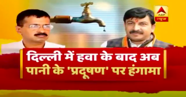
Discussion on politics of Delhi’s dirty water | ABP Hindi News
Professor Manohar Khushalani was invited on a panel discussion on ABP News with the anchor Romana Israr Khan on the segment ‘Samvidhan Ki Shapat’, on Monday, the 18th of November at 5 PM.
The panel began with an introduction about the political twist in the heated pre-election environment on the report on the quality of water in Delhi released by Ram Vilas Paswan, the Union Minister of Consumer Affairs, Food and Public distribution. The claims of terrible water quality were refuted and questioned by Arvind Kejriwal, of the Aam Aadmi Party.
(Professor Manohar Khushalani with Mr. Harish Khurana, Mr. Haroon Yusuf, Mr. Raghav Chaddha and the anchor Romana Israr Khan)
Along with Professor Manohar Khushalani, the ex-director of National Water Academy, Mr. Harish Khurana, the spokesperson for BJP, Mr. Raghav Chaddha, the spokesperson for AAP and Mr. Haroon Yusuf, the spokesperson for INC were present in the panel debate.
The debate opened with Mr. Chaddha claiming that Mr. Gajendra Singh Shekhawat, the Minister of Jal Shakti had previously reported in September that the quality of Delhi’s water fared even better than the water quality in Europe and that Mr. Manoj Tiwari had agreed to the claims. AAP refuted the claims saying the samples were selectively chosen and misconstrued to present a defeating image, citing political reasons. It is important to remember that the World Health Organization states that 80% of India’s groundwater is contaminated by various organic and inorganic pollutants and that India is ranked 20th out of 122 countries in WaterAid’s water quality index. Mr. Khurana refuted the previous report by Minister of Jal saying his statements are being distorted to suit a narrative and the state of India’s water quality is grim and unfortunate. This discussion revolving Delhi’s water quality is of immense importance as approximately 2439 people have lost their lives in 2018 alone to various water-borne diseases such as Chlorella, Typhoid, Hepatitis amongst others. Mr. Manohar elaborated on the technicalities behind report finding and lauded the authenticity of the Bureau of Indian Standards but went on to state how 11 reports alone weren’t enough to gauge the quality of water, especially citing the lack of information surrounding the report. A very significant point was bought to notice by Mr. Manohar who reminded us of the importance Air and Water quality holds to the residents of every area, how previously our surface water was clean and the storm-water drains created during the British era were perfectly functional. But with the advent of covered up drains and Unauthorized colonies, Chemical farming, usage of fertilizers has led to a decrease in the quality of water and improper sewage system has caused our water to pollute.
The extremely heated and informative discussion ended with anchor divulging into the importance of Air and Water quality to the standard of living of the citizens of the country, and how it is important that the politicians look beyond the politics and genuinely improve the quality for the people. You can watch the entire discussion and find more information here- Panel Discussion on water
You can find more relevant information and discussions surrounding Water on this playlist attached above.
बिन पानी सब सून – How to tackle the water crisis / Manohar Khushalani
IIITD Student B.Tech Project. BTP Supervisor: Prof. Manohar Khushalani
Channel One’s half-hour program where Prof. Manohar Khushalani elaborated on how to tackle the water crisis in Delhi in a holistic fashion. Recorded in Channel One Studio in Noida, UP in May 2013
With the rising temperatures in Delhi, the need and demand for water are also rising. The water supply in the capital is becoming worse day by day. Even after multiple promises made by the government, the pressing issue still remains and is in fact growing.
There are many ways in which the situation can be tackled but planning is required. The demand and supply have to be met. The amount of groundwater used is currently more than what is being percolated back. Most of Delhi is located on a hill and groundwater has a little to no existence there. Even the villages where water used to be abundant have very less water now.
Delhi Jal Board has introduced a GPS tracking system for the tankers to prevent stealing and black marketing. The government is also working on directing the water in the right canals which will increase the percentage of water that can be used. The system has been made but even after multiple complaints and requests, there’s no action being taken regularly.
Prof. Manohar Khushalani adds some solutions to the problems. He states that the water level was high years back even when Delhi was a hilly area. So there might have been some mismanagement behind the issue at hand today.
Sewage treatment is also very necessary because otherwise rivers get polluted by the sewage. Sewage farms have been replaced by construction of buildings. Dilution of water has become impossible after people started covering the gutters. These stormwater drains have been made by using public tax money and no one has the right to block them. A formal penalty will be the best solution to this problem.
The calls received in the panel discussion shows how people are frustrated with the situation. They usually get dirty water, which happens because the mainline gets mixed with the sewage line. One caller suggests that an RO system or any water-purifier system can be used in a locality. Jal Board needs to make sure that the voices of people are heard so that better decisions can be made in regards to providing clean water.
Prof. Manohar Khushalani appeared Live, as a Panelist in the Lok Sabha TV Program INSIGHT on, Monday, 18th June 2018 at 1 pm and again at 4 pm. The discussions were on Niti Aayog’s report, titled ‘Composite Water Management Index’ (CWMI). An intense and productive discussion was held on issues confronting the nation concerning the water crisis in India and the world. Dr. T. Haque, from Niti Ayog, was Khushalani’s co-panelist. Pratibimb Sharma was the Anchor of the Program
According to Niti Aayog’s report on water scarcity published in 2018, India is going through the worst water crisis situation it has ever seen. More than sixty crores of its population are facing this issue and around two lakh die every year. This report discusses the plans made by the government to curb this issue and the position they have reached to achieve the goal in the predicted timeline. This has been done in order to make a competitive framework between the states to keep a check on where they stand and what they can do to get to a better situation.
Twenty-one cities including Indore, Bhopal, and NDMC area have switched to the cleaner city lists after constant efforts. According to the rankings, 5 states – Gujarat, Madhya Pradesh, Andhra Pradesh, Karnataka, and Maharashtra are working the most towards fixing the situation. Their practices have been mentioned in the report as an inspiration for other states to see and apply. These ranks have been given on the basis of 9 key areas, for example, the state with best groundwater plans has been given 15 points, improvement in lakes and other water bodies is given 5 points, and so on.
The discussion takes us through the gaps between what the report discusses and the major issues that need to be tackled. The report informs us about what the states have done by far but will this help to intercept the problems that lie in front of us in time?
Prof. Manohar Khushalani then adds that the country is receiving the required amount of rainwater, but the problem is that it is not managed well by the government and the citizens. Reasons being lack of awareness among citizens, constant fighting between states, and inability or lack of knowledge to conserve rainwater. We are a lucky nation to have this huge amount of rainfalls spread across the country but we lack proper planning. One holistic approach is needed towards making and managing proper schemes.
According to Dr. T Haque, awareness has increased amongst citizens in the civil society and they are taking steps to increase the water harvesting practices but facts say that leakages at houses contribute to a large percentage of water being wasted.
Khushalani also talks about the 70 percent water being contaminated as mentioned in the report. It is very important that the water that goes below the ground is being filtered. The water below the ground is connected. So, it is very important to monitor water harvesting as well.
Talking about the utilization of water among farmers, when they were given the free electricity incentive they started using groundwater more than required. Now, when they are asked to use less water or practice micro-irrigation to grow their crops, they have no incentive to be drawn to this new practice. This is a very big area where the government can focus on. Even for the citizens, this is a big question that can come up, what’s in it for me?
There has been a lack of vision despite the efforts taken by the government. The state and the central government needs to be aligned to make better decisions. It is very much possible as some of the decisions taken in the past have proved to be very fruitful. The report has helped in creating awareness in terms of where the states stands and the positive impact of this will be seen in the coming future. This report with the inputs of people will help create a better understanding of what more needs to be done in order to solve the crisis at hand.
Chain of Massive Surprises in Two Punatsangchhu Projects – Yoginder Sharma
CHAIN OF MASSIVE SURPRISES IN TWO PUNATSANGCHHU PROJECTS
– Huge Setbacks Due To Failed Assessments Of Geology & Rock Supports
There is a strange coincidence of massive geological surprises and huge rock mass failures, which happened in the two mega hydroelectric projects named Punatsangchhu -I & II H E Projects, under construction since 2009 -10 in Bhutan.
The Punatsangchhu-I Hydro Electric Project (PHEP-I) a 1200 MW project with scheduled commissioning date of year 2016 at cost of Rs. 35146 millions, new approved Cost of Rs. 94000 millions (US$ 1.34 billions), expects further escalation in its cost possibly to Rs. 121000 millions (US$ 1.74 billion). The Head race tunnel and Desilting Arrangement lying completed since 2015, Powerhouse complex 98% ready have an already incurred cost of about Rs. 80000 millions . However, even the start of concreting for construction of 136m high dam is a big uncertaintyafter its Right Bank suffered a massive slide with continued movement of the big hill mass about 1000m height towards valley and downstream by 5m and vertically subsiding by 5m in a week in July 2013.The hill mass movement has continued at slower pace for more than year, sliding on SZ-2 Shear Zone.
The Punatsangchhu-II (PHEP-II), a 1020 MW project with scheduled date of commissioning of year 2017 at cost of Rs. 37778 millions, new approved project cost of Rs. 72900 millions ( US $ 1.04 billions), expects further escalationin its cost to Rs. 80000 millions ( US $ 1.14 billions), with already incurred cost of about Rs. 65880 millions, is delayed due to the huge rock mass failure in its underground Downstream Surge Gallery (DSSG), resulting in a huge cavity of about 91m height x 70m length and 45m width in the crown of the DSSG. The Dam foundations had encountered, a thus far unexplored,mega shear of maximum 30m width, cutting across the length all the 4 dam blocks diagonally. The shear zone with its about 35ᵒ to 45ᵒ dip, continued under the foundations to large depths.
Occurrence of too many geological surprises, the apparent cause of the big mishaps in the two mega Projects,intrigues one to investigate if ‘ harping on thegeological surprises‘ was only a scapegoat for the lack of proper geological investigations and inappropriate design done by the Consultants.
1. PHEP-I Dam Right Bank Failure :
Shear Plane Continuity in to the hill was NOT detected by Consultants from Geological Investigations done in 2011 and therefore not provided for in Design of rock support for excavated slope
SZ-2 Shear Zone, the cause of the huge hill mass slide, delineated to be dipping sharply in to the hill was established through additional drill holes done in 2014, but only after the slide in 2013.
* Read full story in next article
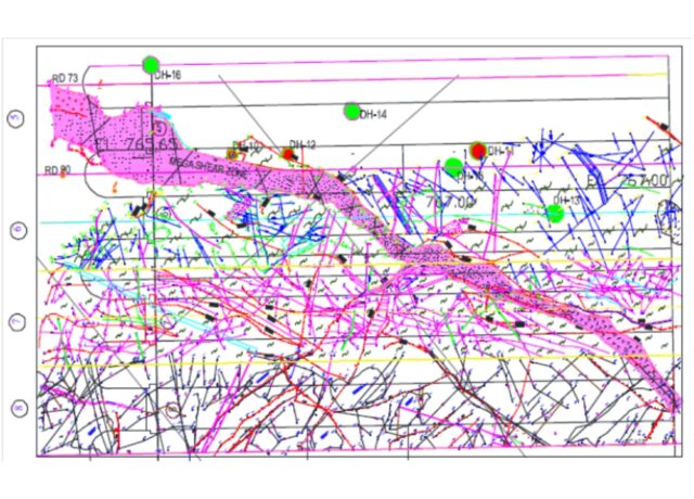
2. Mega Shear Encountered In PHEP-II Dam Foundations
Geological X-Section At Dam Axis (DPR Stage) Shows No Shear Zone in the Dam Foundations
Geological X-Sections Depicting Shear Zone at Dam Axis, Ch. 40m,60m and 80m D/S of Dam Axis
Shear Zone Traverses From Heal in Block 5 to Toe in Block 8with Trend 35ᵒ-45ᵒ/N070 -080 With Affected Zone 4m to 30m Wide
* Read full story in separate article coming up shortly
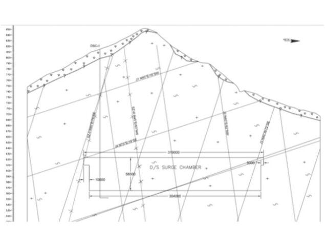
3. Huge Rock Mass Failure In DSSG of PHEP-II :
Geological X- Section of DSSG Assessed By Consultants Showed No Shear Zone
The massive rock fall in the Downstream Surge Gallery Cavern happened on 03 March 2016 during the progress of benching excavation in the cavern. The cavern had been excavated to its 2/3 rd depth and the crown stood intact for three years before the rock fall. Six technicians of those working in the cavern at the time of collapse got buried alive under the falling muck and died.
* Read full story in separate article coming up shortly
The individual case studies of the Rock Mass Failure in Punatsangchhu-I Dam ; Encounter of Un-Explored Mega Shear zone in Punatsangchhu-II Dam; and The Huge Rock Mass Failure in DSSG of Punatsangchhu-II HE Project, dealt in details, shall be posted separately soon please.