The Secret of Israel’s Water Miracle and How It Can Help a Thirsty World

Indian Prime Minister Modi’s visit to Israel has put spot light on Israel’s phenomenal research in the field of water conservation. This article reproduced by Haartez would be of interest to our readers

http://www.haaretz.com/israel-news/science/1.698275


Water Conservation Faucet

Water shortage is a huge problem in several countries. Many households, however, still use water without paying attention to how much they use. A Kickstarter-backed company, Altered, created a simple device that aims to reduce water waste that comes from running faucets.


Presto! Water from thin air!!

An Arizona State University spin-off company, Zero Mass Water, is creating access to water for all, just like the air we breathe.
Their special solar panels pull vaporize the air, condense it into water and then filter it using minerals.


In Ladakh Sonam Wangchuk Creates his own Glacier

Sonam Wangchuk lives and works in the Ladakh region of India, high in the Himalayas. This harsh mountain area is experiencing acute water shortages due to climate change. Sonam, who is an engineer and educator, found a simple but ingenious way to store water using artificial glaciers that will irrigate trees and crops.


Naini Lake Water Level Dips by 18 ft

Nainital Lake water level falls by 18 ft. Please watch this program with Prof. Manohar Khushalani on National Television regarding the serious water crisis facing the world


Pakistan floods reveal deep-rooted problems

Co-operation with countries in the Indus basin for building storage dams, flood control installations and power generation stations will help Pakistan.

Santosh Kumar

Manohar Khushalani

The floods in Pakistan may have abated but the havoc caused by them continues to mount. Nearly 21 million, or 13 per cent of Pakistan’s population, and 20 per cent of its area have been affected. About 1.85 million homes have been destroyed or damaged in a country where a large percentage of the population live as refugees. UN experts estimate that 2.7 million people in Khyber Pakhtunkhwa, 5.3 million in Punjab and 4.4 million in Sindh need immediate humanitarian assistance.

The damage caused to agricultural land and livestock will take years to set right. Approximately four out of five people in the flood-affected areas depend on agriculture for their livelihood. An estimated 700,000 acres of cotton, 200,000 acres each under rice and sugarcane and 300,000 acres of wheat crops have been destroyed. This will severely affect the agricultural economy, which accounted for 20.4 per cent of Pakistan’s GDP last year. The cascading effects on industry and trade are bound to add to the economic woes.

Relief efforts

The political spillover is equally, if not more, worrisome. Relief efforts highlight the inefficiencies and corruption endemic in the Pakistani administrative set-up, magnified as they are in the eyes of the already disenchanted masses, especially the internally displaced. The fear is that fundamentalist organisations will extend their grip over the affected populace by filling the wide gaps in disaster relief left by the Pakistan Government and international relief agencies.

Even if Pakistan tides over the after-effects of these floods, can it prevent another such disaster? Pakistani meteorological data point to the unusually heavy rains in July-August in the Khyber Pakhtunkhwa and Punjab provinces as the main cause of the floods. The precipitation map released by USAID corroborates this.

Indus River basin

The flood-affected areas are mostly along the main Indus River and its western tributaries — Swat and Kabul — and less so along the eastern tributaries — Jhelum, Chenab and Sutlej.

This should not, however, obscure the larger picture. More than 80 per cent of the total water flows in the Indus River system. The water originates from snowmelt and rainfall in the wider mountainous arc, which includes Afghanistan, India and China.

According to one estimate, the Kabul River accounts for 20-30 maf (million acre-feet) of total annual flows, the main Indus 100 maf, the Jhelum and Chenab 60 maf, while the Ravi, Beas and Sutlej add another 40 maf or so.

Floods are a cumulative effect of all these flows and are triggered almost annually, with constant siltation reducing the rivers’ capacity to hold these waters. Rising precipitation levels over the long term are likely to result in even more unmanageable discharges.

Historical records indicate that about 6,000 years ago, the Indus was more powerful and prone to flooding than today. Then, as the climate cooled some 4,000 years ago, a large part of it simply dried up. It is possible that global warming will reverse this trend.

Initially, storage dams such as Mangla and Tarbela were built to aid irrigation and control floods. But they are beset by silting problems as the Indus is one of the largest sediment-bearing rivers in the world.

Water storage capacity has already been reduced to 17.1 maf as against the original built capacity of 64.4 maf. And Pakistan has been singularly unsuccessful in building additional storage capacity to compensate for this, let alone provide for enhanced irrigation and flood control needs.

A major project, the Kalabagh dam, has failed to get off the drawing board for two decades because of internal bickering between the provinces. The result is that the existing dams are virtually unable to retain any water during the monsoons. It is evident that outflows equal inflows in almost all major reservoir locations, except for Marala, on the Chenab, which has been able to absorb some water.

International segmentation

Moreover, the international segmentation of the Indus basin rivers complicates the problem further. The mighty rivers follow their own course and do not recognise man- made political boundaries. Their upper reaches, except for the Swat, are largely beyond Pakistan’s political control. And with the two principal upper riparian states — India and Afghanistan — Pakistan has a troubled relationship.

With India it does have the Indus Treaty but the provisions basically partition the waters, giving those in the main river, Chenab and Jhelum, to Pakistan. There is no agreement at all with Afghanistan on the Kabul River. The result is that the flows in these rivers enter Pakistan unhindered by any storage capacities, even during floods.

Question of choice

Pakistan is, thus, at a fork in the road. It can either continue policies which underlie the present arrangements (or the lack thereof) and face similar or perhaps bigger flood disasters in future if anticipated climate change effects materialise.

Or it can chose to cooperate with countries in the Indus basin in building storage dams, flood control installations and power generation stations, which will help modulate flows and thereby benefit Pakistan’s agriculture, particularly its struggling farmers.

The attendant hydropower potential is also huge and can be tapped for the energy-hungry Pakistani economy as well as for cross-border sales to India. But for all this to happen, integrated basin management is required.

The big question is whether Pakistan’s rulers can change their confrontationist mindset to make this possible. And whether India and Afghanistan can think out of the box to adopt a more imaginative and generous approach towards what can be a win-win situation for the people of all three countries.

(This article was published in the Business Line print edition dated October 19, 2010)


Pakistan – From Floods to Fiasco

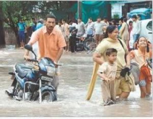
The floods in Pakistan now show signs of abating but the havoc caused by them will continue to mount.  It is too early to measure even the immediate losses of lives or property, both private and public, although over 2000 persons are estimated to have died and 21 million become refugees in their own country.  Secondary damages to agricultural land and animal husbandry will take years to recoup.  At one point about one-fifth of Pakistan’s total land area had gone under water.  Floodwaters have destroyed crops :  an estimated 700,000 acres of cotton, 200,000 acres each of rice and sugar cane and 300,000 acres of wheat.  This will impact the agricultural economy which contributed 20.4% of Pakistan’s GDP last year.  The cascading effect into industry and trade is bound to add to economic woes.

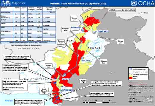
Pak Flood affected districts as on 6th September 2010 – (Source OCHA)

Scientists have described this catastrophe as a once-in-a-century flood. Out of a Population of 168 million nearly 21 milion people have been affected by floods out of a total area of Pakistan of 796 095 square kilometers, the Flood-affected area is 160 000 square kilometers. In a country where already a large percentage of the population is living as refugees, an additional 1.85 million homes have been destroyed or damaged due to floods. Look at the fact sheet of the present disaster:

Pakistan Flood Losses (as on 6 September 2010)

Source:  NDMA, PDMA

Province Deaths Injured Houses Damaged Population Affected
Balochistan 48 102 75,261 *672,171
Khyber Pakhtunkhwa 1,154 1,193 200,799 4,365,909
Punjab 110 350 500,000 8,200,000
Sindh 186 909 1,058,862 6,988,491
AJK 71 87 7,108 245,000
Gilgit Baltistan 183 60 2,830 81,605
Total 1,752 2,701 1,844,860 20,553,176
* Additional 600,000 IDPs from Sindh are living in Balochistan

The degree of severity to which people have been affected by the floods varies depending on their particular losses and damages. UN assessments have been launched in at least three provinces to identify severely affected families who require life-saving humanitarian assistance. The UN experts have identified 2.7 million people in Khyber Pakhtunkhwa, 5.3 million in Punjab and 4.4 million in Sindh that are in need of immediate humanitarian assistance.

Approximately 4 out of 5 people in the flood-affected areas depend on agriculture for their livelihood. Across the country, millions of people have lost their entire means to sustain themselves in the immediate and longer term, owing to the destruction/damage of standing crops and means of agricultural production.  One of the greatest challenges on the ground is helping farmers to recover their land in time for wheat planting beginning in September/October and to prevent further livestock losses. According to the FAO figures released on 3rd September 2010, the scale of losses to the agriculture sector caused by the Pakistan floods is unprecedented and further unfolding:

  •  The Agriculture Cluster rapid damage assessments, completed in half of all flood-affected districts, found that 1.3 million hectares of standing crops have been damaged
  •  Countrywide damage to millions of hectares of cultivatable land, including standing crops (e.g. rice,maize, cotton, sugar cane, orchards and vegetables) appears likely
  •  Loss of 0.5-0.6 million tonnes of wheat stock needed for the wheat planting season
  •  Death of 1.2 million large and small animals, and 6 million poultry (Department of Livestock)

While the full extent of the damage still cannot be quantified and assessments are ongoing, the direct and future losses are likely to affect millions of people at household level, as well as impact national productive capacity for staple crops, such as wheat and rice. The FAO feels that response to needs in the agriculture sector cannot be underestimated nor delayed.

The political spillover is equally if not more worrisome.  Relief efforts have highlighted the inefficiencies and corruption endemic in the Pakistani administrative set-up, magnified as it is becoming in the eyes of the already disenchanted masses, especially the internally displaced. The fear is that    fundamentalist organizations will extend their grip over affected populations by filling in wide gaps in disaster relief left by Pakistan Government and international relief agencies.  All this adds fuel to the already political fire in a volatile and unpredictable Pakistan.

Even if Pakistan wades through the floods, what is there to prevent another water disaster in the future?  To answer this question, one must examine these floods in a broader framework.  Pakistani meteorological data points to unusually heavy rains in July – August in the Khyber Pakhtunkhwa and Punjab provinces as the main cause of the floods.  Satellite pictures corroborate this.

Satellite Map shows the swelling Indus River at Sukkur Barrge Source NASA

Satellite Map shows the swelling Indus River at Sukkur Barrge Source NASA


According to a  WAPDA (Water and Power Development Authority) ] press release on Water Situation on 03 – 09 – 2010 the 24 hour Inflows / Outflows (in Cusecs) of the major Dams on the rivers in Pakistan were as follows:

Indus at Tarbela 203300 / 203300 Cusecs

Kabul at Nowshera 42000 / 42000 Cusecs

Indus at Chashma 249100 / 244100 Cusecs

Jhelum at Mangla 42800 / 42800 Cusecs

Chenab at Marala 87000 / 67400 Cusecs.

The above figures indicate that the Pakistani dams/barrages are virtually unable to retain any water, as can be seen above, almost all of the inflows are equal to the outflows. This is normally the case in monsoons for some dams but the figures are shocking because not a single dam except for Marala on the Chenab has been able to absorb some 20,000 cusecs of water.

Balochistan Times (August 21, 2009) reported that since the Chashma Barrage had been filled with water along with Tarbela Dam and Mangla Dam as a result of filling of these water reservoirs, IRSA had directed the provinces to use the released water as much as they needed without any restrictions. According to IRSA (Indus River System Authority)  officials, besides Mangla and Tarbela Dams the approximate inflow of water in the other rivers was 319500 cusecs and 4000 cusecs from river Kabul, all of which was being released as Tarbela and Mangla had filled completely. The CJ canal had been closed so that the Chashma Barrage could be destilled. The plus side for power starved Pakistan was that with the filling of dams with water, the power production had been increased, from which about 4000MW power was being generated from hydel power, which  reduced load shedding in the country..

The flood affected areas were mostly along the main Indus River and its western tributaries – Swat and Kabul; and less so from the eastern tributaries – Jhelum, Chenab and Sutlej.  This should not however obscure the overall picture.  More than 80% of the total water flows in the Indus river- system is accounted for by snowmelt and rainfall in the mountainous regions which are largely beyond its political control and belong to Afghanistan, India and China.  According to one estimate, the Kabul river accounts for 20 to 30 MAF of total annual flows, the main Indus 100 MAF and the Jhelum and Chenab 60, while the Ravi, Beas, and Sutlej add another 40 MAF or so. Floods are a cumulative effect of all these flows.

Initially, storage dams like Mangla and Tarbela   were built to modulate irrigation and control floods. But some 7 MAF of their storage capacity has already been silted up. And Pakistan has been singularly unsuccessful in building additional storage capacity to compensate, let alone provide for enhanced irrigation and flood control needs.  A major project – the Kalabagh dam – has failed to get off the drawing boards for two decades because of internal bickering between its provinces.  The international segmentation of the Indus basin rivers complicates the problem still further, particularly in relation to the two principal upper riparians – India andAfghanistan – with which Pakistan has troubled relationships.

The 3,200 km long Indus, one of the mighty rivers of the Indian subcontinent,   flows down from the Himalayas of Tibet, towards north-west through India before turning sharply southwards through  Pakistan,  draining into the Arabian Sea. Some of its water comes from melting Himalayan glaciers, but the vast majority is contributed by the monsoon. The monsoon floods are triggered almost annually. Historical records indicate that during a warm period ending about 6,000 years ago, the Indus was a monster river, more powerful and more prone to flooding than today.  Then, 4,000 years ago, as the climate cooled, a large part of it simply dried up. Deserts appeared whether mighty torrents once flowed. The matter of public debate is whether, with global warming, will the river again turn monstrous. A matter which further compounds the problem is the fact that siltation reduces the rivers capacity to hold water. Even with the total quantum of precipitation being the same, the intensity of rainfall gets aggravated by global warming resulting in unmanageable discharges.  Pakistan, which spends more of its scarce financial resources in building defences against India, has been unable to enhance its Hydraulic infrastructure comprising  of dams and barrages. In fact, due to siltation its overall storage capacity has further reduced.

Pakistan is, thus at a fork in the road.  It can either continue confrontationist policies which underlie present arrangements (or lack thereof) and face similar or perhaps bigger flood disasters in future, if anticipated climate change effects do materialise. Or it can chose to cooperate with countries in the Indus basin with a view to building an integrated system of storage dams, flood control installations and power generation stations which will help to modulate flows and avert floods, thereby benefitting Pakistan’s agriculture particularly its struggling farmers. The attendant hydropower potential is also huge and can be tapped for the energy-hungry Pakistani economy, as well as cross-border sales to India.  The big question is whether the Pakistan’s rulers can change their confrontationist mindset to make this possible.  If there was no deficit of trust India could have stored water even in the eastern rivers of the Indus basin to be used as a kind of buffer during floods. But, for that an integrated basin management is required, because the mighty rivers, follow their own course, they do not recognize man made political boundaries.

A  Condensed version of this article was first published in Hindu Business Lineon 19th October 2010. Business Line version is available on the net at the following URL:

http://www.thehindubusinessline.com/2010/10/19/stories/2010101950330900.htm


Acronyms

NDMA National Disaster Management Authority

WAPDA Water and Power Development Authority

IRSA Indus River System Authority

OCHA United Nations Office for the Coordination of Humanitarian Affairs

FAO Food and Agriculture Organisation

IDP Internally Displaced Person

MAF Million Acre Feet

Cusec Cubic Feet per Second


India’s Leap Forward : Country’s Largest Desalination Plant Opens in Chennai


CHENNAI STATISTICS

Geographical Area

175.33 Sq.Km.

Latitude / Longitude

13º04’ North / 80º15’ East

Population

6 Millions

Topography

Flat

Drainage

Araniyar,Kortaliyar, Adayar & Coovum

Average Rain fall

1400 mm per year

Temperature

30º C to 40º C

Climate

Tropical

Humidity

Vary between 65% and 80%

Water Supply Sources

Surface and Ground water

Water Supply
(Normal year)

440 Mld

Supply Rate )
(Normal year)

70 – 100 lpcd

India’s largest desalination plan twas inaugurated in Chennai on Saturday the 31st July. The facility will draw water from the Bay of Bengal, process it using the reverse osmosis technology and supply purified water to the city. The joint venture between IVRCL Infrastructures and Project Ltd and Befessa

Chennai Water Desalination Ltd RO Plant

of Spain, spread across 60 acres, has been built at a cost of  Rs 600-crore at Minjur. It can desalinate 100 million litres of water per day, sufficient for around 2 million people. Thus it would cater to half of Chennai’s population of about 4.5 million. What is most interesting is the fact that the plant will supply water to the Chennai Metropolitan Water Supply and Sewerage Board at a cost of just about 5 paise per litre for the first 25 years. The competitive pricing is because the facility adopts an energy-conserving desalination process, According to CMWSSB officials yet another desalination plant with similar capacity is expected to come up in Tamilnadu by 2012.

Earlier, in January this year, Saudi Arabia’s national science agency announced a new initiative to build solar-powered desalination plants to reduce water and energy costs by 40 percent. For Saudi Arabia there had been no breakthrough in the cost of desalination. The gradual reduction in cost due to improvement in technology had been mostly offset by increased material and labor cost. The initiative will be carried out in several stages, and the first plant will be a small, 30,000 cubic meter per day facility in Al-Khafji. In comparison, the Shoaiba 3 project on Saudi Arabia’s west coast is the world’s largest plant, producing 880,000 m3/d .During the initiative’s second phase, a 100,000 m3/d plant will be built. Eventually a network of plants across the country.


Water Issues Between Riparian States : India and Pakistan

Water is a bone of contention between neighboring states competing for control of those resources. Since 1948, nearly 40 incidents of hostilities have taken place over water. Of the world’s 263 international basins, Asia alone has 57 basins.  The Himalayan rim of South Asia are a key sub-region for examining the impact of water as a negotiating vehicle for promoting cooperation and prosperity.

India

Over the past 150 years India has made large investments in large scale water infrastructure, much of which brings water to previously water-scarce areas. This has resulted in a dramatic economic shift, with once-arid areas becoming the centers of economic growth, while the historically well-watered areas have seen much slower progress. For the most part the results of this “hydraulic infrastructure platform” have been spectacular both nationally (through the production of food grains and electricity, for example) and regionally (where such projects have generated large direct and equally large indirect economic benefits). The poor have benefited hugely from such investments. The incidence of poverty in irrigated districts is one third of that in unirrigated districts[1].

Two-thirds of India’s water resources potential come from only two river basins namely, the Indus and Ganga-Brahmaputra-Meghna (GBM). India occupies a unique position in this respect. There is abundance of Water and Hydro Power potential within the country and in its neighbouring states. The potential can be used both constructively as well as destructively. The first decade of the millennium has been marked by what has often been described as oil wars – confrontation over dwindling hydrocarbon fuel resources. Will the next decade be marked by confrontation over water and hydro energy, or will it be known for cooperation over sharing the natural resources?

One source of optimism is the fact that India has successfully drawn up water resources related bilateral treaties with three of its Asian neighbours – Pakistan, Nepal andBangladesh.


Indo-Pak

With Pakistan, it was the Indus Water Treaty which has completed a mind boggling 48 years of successful implementation. Since its coming into force in 1960 only once in 1999, after construction began, Pakistan claimed some design parameters of Baglihar project violated the Indus Water Treaty. Indus Water Treaty had provided India with exclusive control to three eastern rivers while Pakistan with exclusive control to three western rivers, including Chenab River. However it contained provisions for India to establish river-run power projects with limited reservoir capacity and flow control needed for feasible power generation. Availing the provision, India established several run-of-the-river projects most of which were not objected to by Pakistan. However, in case of Baglihar and Kishan-Ganga projects, Pakistan claimed that some design parameters were more lax than needed for power generation and provided India with excessive ability to accelerate, decelerate or block flow of river. This, it was felt, may give India a strategic leverage in times of tension or war.

During 1999-2004 India and Pakistan held several rounds of talks on the design of projects, but could not reach an agreement. After failure of talks on January 18, 2005Pakistan raised six objections and took up the matter with the World Bank, which was a broker and signatory of Indus Water Treaty. In April 2005 the World Bank determined Pakistani claim as a ‘Difference’, a classification between less serious ‘Question’ and more serious ‘Dispute’ and in May 2005 appointed Professor Raymond Lafitte, a Swiss civil engineer, to adjudicate the difference.

Lafitte declared his final verdict on February 12, 2007, in which he partially upheld some objections of Pakistan declaring that pondage capacity be reduced by 13.5%, height of dam structure be reduced by 1.5 meter and power intake tunnels be raised by 3 meters, thereby limiting some flow control capabilities of earlier design. However he rejected Pakistani objections on height and gated control of spillway declaring these were conforming to engineering norms of the day.

Both parties (India and Pakistan) have already agreed that they will abide by the final verdict. This peaceful settlement of the only major discord in nearly half a century is an even greater achievement, considering the fact that the two neighbors have gone to war thrice on other issues.


[1] World Bank Report, India’s Water Economy: Bracing for a Turbulent Future, John Briscoe


Why is Delhi Water Logged It’s Drains and Sewers Clogged

by

Manohar Khushalani


A city like Delhi which draws its water from the river, follows a cycle similar to the Hydrological Cycle of Nature.  Water is supplied by the municipalities to the residents.  Some of the water is utilized for drinking purposes, some for watering the gardens and some for cleaning, washing and bathing and some for flushing the toilets.  The latter two ideally enter the sewage system.  The rain that falls over the city enters the storm water drains which empty into huge nullahs, which in turn empty into the river Yamuna.

This system can also enable rain water harvesting because the storm water drains can be utilized for water harvesting in an organized fashion.  But the storm water drainage system of Delhi is complex owing to a combination of natural and man made drainage systems – drainage basins which naturally drain, storm water drains along the roads and a new phenomenon of combined sewer cum storm water drains created as a bypass arrangement for blockage sewer lines.  It is this that has resulted in polluting the storm water drainage system.  As a result, the nullahs which used to run with rain water during monsoons now carry only sewage.

What is also being done, using Common Wealth Games as a shield, is to cover up the nullahs.  Now, this is really like putting dirt under the carpet.  This reminds me of a fable, in which, when a rabbit is confronted by pointing a gun at it, all it does is to cover its eyes with its ears.  The rabbit thus thinks that the threat no longer exists, but, it gets shot in any case! When you hide the threat you don’t necessarily solve the problem you only ignore it … until it becomes bigger.  Even if some sewage was reaching the nullahs, the rain water used to ensure that the viscous or solid waste content was appropriately diluted and thus the effluent reaching the river would not be as heavily polluted as it is today.

When residents cover or even fill up the storm water drains outside their houses to help park their cars or when the sarkari sweepers (employed by the municipality) also dump garbage into the open drains, it prevents rain water from reaching the nullahs and ultimately the river.  Blocking a drain should be treated as cognizable offence, because it is equivalent to sabotaging a public utility on which tax payers money has been spent. Historically it is said that the drainage system of Old Delhi was largely developed by the Mughals whereas of New Delhi by the British. It used to work fine until it was vandalized by us humans.

Often non working of a system is used as an excuse to reinvest in a new system which involves public expenditure. For example, a recent report tabled by the Committee on Petitions, Legislative Assembly of Delhi, while hearing a petition filed by a Delhi-based NGO, CHETNA, has highlighted the fact that the majority of the drains of Delhi have been settled and nothing can be done about it. It has also brought out the fact that in many cases even the design of the drains is faulty. The report suggests an urgent need for reconstructing the drains.

The other finding of the Committee, regarding resuscitation of the existing system makes interesting reading. While criticising the municipal authorities for indulging in cosmetic de-silting of drains, the Committee has observed that tenders were issued with the condition that payment would be released on the basis of actual quantity of silt removed. As a result, the contractors remove only just as much silt as is easily removable and leave the difficult and hardened part of it alone. According to the committee the tender document should clearly specify that the contractor’s payment will be released only after the bed level for each drain is achieved, for which work has been awarded to a given contractor. The bidder should be aware that he is not going to be paid for cosmetic exercise but actual de-silting which includes the stubborn silt. Moreover, the process of de-silting should be backwards from the outfalls towards colony drains. De-silting would of course be useful only when waste water actually finds its discharge into the outfalls.

The last Master Plan for storm water drainage of Delhi was prepared by the Master Plan Organization set up by the Irrigation and Flood Control Department during the period 1972-1976 (finalized in 1977). An Expert Committee was set up by the Delhi Administration to give guidance to this activity. This Master Plan took into account the urbanization limits up to the year 1981. However, while according approval, the Committee of Experts suggested that a fresh review of the drainage issues be taken while doing the Master Plan – 2021. Till date the Master Plan for storm water drainage of Delhi has not been revised.

The existing capacity of the sewage treatment plants in Delhi is under utilized due to of deficiency in the collection system and choking of existing sewerage, failure of pump connections and trunk sewers, internal sewers and peripheral sewers. The trunk sewers are 136 kms long and are heavily silted. The large network of (6000 km) peripheral sewers is very old and some of them are under sized and also in damaged condition. Central Pollution Control Board (CPCB) carried out inspection and monitoring of sewage treatment plants (STPs) in Delhi to verify the utilization of sewage treatment capacity and their performance during November-December 2003. They concluded that out of 3267 mld of sewage generated, treatment capacity exists for 2330 mld (71%), and actual treatment is given to only about 1478 mld which is just 45% of total sewage generated. Part of the wastewater generated is collected through underground sewers and transported to the treatment plants and balance flows into the river Yamuna through 22 drains. There are total 28 industrial estates in and around Delhi which contribute 218 mld wastewater (either treated or untreated) in to the open drains.

One also recalls that there used to be sewerage farms along with the river Yamuna where the sewerage system was providing water and nutrients to the crops and therefore the water reaching the river was cleaner.  Now if you travel along Mathura Road in Delhi you will find that the sewage farms have been sold off for development of Malls and other concrete structure.  The net result is that Yamuna itself has started looking and smelling like sewage canal.  Instead of cleaning the river is it not better to clean the effluent entering the river.  If the source of the problem is not tackled, it matters little how much money you pump into the river, you just cannot pump out the sewage.

Another interesting phenomenon, prevalent not only in Delhi but in most cities, is, that garbage is always dumped near the river.  Therefore, when the rains come, that garbage too finds its way into the river.  Now the river in Delhi does not spring out at the city itself but comes down from the Himalayas collecting water and effluent along the way.  For the river to flow smoothly, the unobstructed route through which it flows ensures how much water can pass.  Silting of course reduces the depth and the width of the river. But the problem is compounded by man. The tragedy of Yamuna is that when the city was faced with constraints of space, the authorities that be, allowed construction in the river bed, thus reducing the cross section of the river and creating the situation for future disaster.

Earlier in the river bed, during the non monsoon period, agricultural farming used to take place. This was in no way harmful; because when the rivers ran full during the monsoons; it used to leave a coat of fertile silt on the farm beds and the greenery thus grown also acted as a lung for the city.  Now, the infrastructure developments on the river front, with Akshardham temple and games village coming up, will encourage others to encroach into the river and ultimately destroy the hydrological cycle of the city.


August 4, 2010

copyright Manohar Khushalani and UnoUniverse.com


Bibliography:

  • Irrigation Practice and Design, (Volumes I, II,III, IV & V) K.B. Khushalani & Manohar Khushalani Pub; Oxford & IBH (Sponsored by National Book Trust)
  • Control of Urban Pollution Series:CUPS/ / 2003-2004, CPCB
  • City Development Plan , Department of Urban Development, Govt. of Delhi / IL&FS/October 2006,